
Garmin eTrex 10
4.3Editor score
Preloaded worldwide basemap
IPX7 waterproof
20 hour battery
Finding the right handheld GPS for geocaching can transform your outdoor adventures from frustrating hunts into seamless treasure finds. A reliable device ensures you locate caches even in dense forests or deep canyons where smartphone signals often fail.
We have carefully evaluated ten top-rated models based on critical criteria including display readability, battery endurance, satellite support, and specialized geocaching features. Our analysis focuses on devices that balance performance with durability for real-world outdoor conditions.
Each product selection includes detailed specifications and honest assessments of strengths and limitations. Please note that product availability and pricing fluctuate frequently, so verify current details on the retailer site before making your final purchase decision.
4.3Editor score

4.2Editor score

4.1Editor score
As an Amazon Associate we earn from qualifying purchases.
The following comparison table provides a side-by-side overview of the ten selected handheld GPS units, highlighting key specifications that matter most to geocachers such as display size, battery life, and preloaded map features.




The Garmin eTrex SE stands out as a top contender for geocachers seeking reliability without breaking the bank. With a 4.2 rating from verified users, it combines essential navigation features with impressive battery endurance suitable for multi-day expeditions.
We may earn a commission when you buy through this link, at no additional cost to you.
Its standout feature is the extended battery life offering up to 168 hours in standard mode using two AA batteries. The high-resolution 2.2-inch display ensures clear visibility even under harsh sunlight conditions. Pairing with the Garmin Explore app enables wireless updates and automatic cache details which streamlines cache finding.
While it lacks preloaded detailed maps compared to higher models, the lightweight design and robust IPX7 water resistance make it ideal for day hikes. The reliance on a smartphone for complex mapping tasks might be a drawback for offline-only users.
This device is perfect for intermediate geocachers who prioritize battery life and ease of use over advanced mapping features. It balances cost and functionality effectively making it a strong choice for regular outdoor navigation.
The 168-hour standard battery mode ensures you can go days without changing batteries during extended trips.
Automatic cache updates from Geocaching Live keep your device current with new cache details without manual input.
We may earn a commission when you buy through this link, at no additional cost to you.
The Garmin eTrex 10 is an excellent entry-level choice for those new to geocaching or seeking a backup device. Its 4.3 rating reflects user satisfaction with its rugged build and straightforward interface that minimizes learning curves.
We may earn a commission when you buy through this link, at no additional cost to you.
Key strengths include its lightweight form factor and preloaded worldwide basemap which helps basic navigation without extra costs. The WAAS enabled GPS receiver ensures fast positioning and reliable signal lock even in challenging terrain. Paperless geocaching support allows storing cache data directly on the device.
The monochrome display may appear dated compared to color screens but remains readable in most lighting conditions. Limited internal memory means you may not store extensive additional maps without external expansion options.
For casual geocachers or travelers needing a dependable global GPS unit the eTrex 10 delivers essential functionality at a minimal cost point. It is best suited for those who value simplicity and portability over advanced mapping features.
The preloaded worldwide basemap provides immediate usability across different countries without needing additional map purchases.
Waterproof to IPX7 standards ensures protection against rain and accidental splashes during outdoor adventures.
We may earn a commission when you buy through this link, at no additional cost to you.
The Garmin GPSMAP 66s offers premium navigation features in a renewed package that appeals to budget-conscious enthusiasts needing advanced tools. Its 4.0 rating indicates solid performance despite being a refurbished item with full functionality restored.
We may earn a commission when you buy through this link, at no additional cost to you.
A standout benefit is the large 3-inch sunlight-readable color display which enhances map clarity significantly. The built-in BirdsEye Satellite Imagery subscription allows direct-to-device downloads of aerial views useful for locating cache spots visually. Multi-GNSS support including GPS GLONASS and Galileo improves tracking accuracy.
Users should note that renewed units may have minor cosmetic imperfections though they function like new. The higher price compared to basic models might not justify for simple cache hunting but excels for serious hikers requiring topographic data.
This device is ideal for adventurers who need reliable topographic details and large screen real estate for navigation. The combination of wireless connectivity and premium sensors makes it a robust choice for demanding outdoor environments.
BirdsEye Satellite Imagery provides aerial views that help identify terrain features and potential cache locations clearly.
Multi-GNSS support ensures faster and more accurate location tracking even in dense forests or deep canyons.
We may earn a commission when you buy through this link, at no additional cost to you.
The Garmin eTrex 22x is a reliable mid-range option that balances performance and affordability effectively. Its 4.3 rating reflects user appreciation for its rugged build and preloaded maps which simplify initial setup and use.
We may earn a commission when you buy through this link, at no additional cost to you.
Key strengths include the 2.2-inch sunlight-readable color display and 8 GB internal memory for map downloads. Preloaded Topo Active maps provide routable roads and trails ideal for hiking and cycling. Support for GPS and GLONASS ensures better tracking in challenging environments.
Battery life is respectable at 25 hours but falls short compared to extended-life models. The lack of a camera means you must rely on external devices for documenting finds or scenery during your hikes.
This device is suitable for geocachers who want ready-to-use maps without extra subscriptions. It offers a solid balance of features for regular outdoor use without the premium cost of higher-end models.
Preloaded Topo Active maps eliminate the need for initial setup and provide immediate navigation routes for outdoor activities.
The micro SD card slot allows adding custom maps and expanding storage beyond the built-in 8 GB memory.
We may earn a commission when you buy through this link, at no additional cost to you.
This third-party handheld GPS offers impressive hardware specifications at a competitive price point for users seeking alternatives to major brands. Its 3.9 rating suggests mixed user experiences but highlights strong feature sets like large screens and high capacity batteries.
We may earn a commission when you buy through this link, at no additional cost to you.
The 3.2-inch sunlight-readable screen stands out as a major advantage for map visibility in bright conditions. With up to 36 hours of battery life and USB-C rechargeability it reduces dependency on disposable batteries. Multi-GNSS support and 32 GB memory provide ample room for maps and tracks.
The lower rating may indicate variability in software support or build quality compared to established manufacturers like Garmin. Some users report inconsistencies in sensor accuracy or interface responsiveness during extended use in the field.
For budget-conscious buyers who prioritize screen size and battery life this device presents a viable alternative. It is best suited for those comfortable troubleshooting occasional software quirks in exchange for premium hardware specs.
The 3.2-inch display offers more space for map details and waypoints improving navigation clarity during hikes.
USB-C rechargeability aligns with modern devices simplifying power management and reducing the need for extra adapters.
We may earn a commission when you buy through this link, at no additional cost to you.
The Garmin eTrex 32x builds on the popular 22x model by adding enhanced tracking tools and compass features. Its 4.2 rating reflects satisfaction with its comprehensive navigation capabilities and robust construction suited for varied terrains.
We may earn a commission when you buy through this link, at no additional cost to you.
Key features include the 3-axis compass and barometric altimeter which offer precise altitude and heading data even when stationary. Preloaded Topo Active maps with routable roads simplify route planning for cycling and hiking. The micro SD card slot allows for easy map expansion.
The design closely resembles the 22x which might limit appeal for those seeking distinct upgrades beyond the extra sensors. Battery life remains standard at 25 hours which is adequate but not exceptional for multi-day trips.
This model is ideal for hikers who need accurate elevation and direction data alongside basic geocaching functionality. It offers a reliable balance of tracking precision and map flexibility for intermediate outdoor enthusiasts.
The barometric altimeter provides real-time altitude changes helping you monitor terrain elevation accurately during hikes.
The 3-axis compass ensures accurate heading even when the device is stationary or tilted during navigation.
We may earn a commission when you buy through this link, at no additional cost to you.
The Garmin Oregon 550T remains a popular choice for users who want to capture images of their findings directly on the device. Its 4.3 rating highlights strong performance in navigation and camera integration despite being an older model.
We may earn a commission when you buy through this link, at no additional cost to you.
The 3-inch touchscreen display offers intuitive control and visibility. A 3.2-megapixel autofocus camera allows geotagging photos with coordinates which is perfect for cache logs or documenting scenic points. The barometric altimeter tracks pressure changes to refine altitude readings.
As an older unit it may lack modern connectivity features like wireless updates found in newer devices. The high price on the secondary market reflects its niche appeal rather than current technological relevance.
This device is best for those who prioritize capturing visual memories alongside navigation. It is a solid choice for geocachers who value the convenience of in-device photo documentation without carrying a separate camera.
The built-in camera geotags images automatically making it simple to share visual proof of finds on geocaching platforms.
The large touchscreen interface simplifies map navigation and menu access compared to traditional button-only devices.
We may earn a commission when you buy through this link, at no additional cost to you.
The Garmin Montana 680 represents a premium tier of GPS devices combining high-resolution imaging with extensive geocaching features. Its 4.1 rating indicates strong satisfaction among users who need advanced organization tools and superior hardware.
We may earn a commission when you buy through this link, at no additional cost to you.
One of its most valuable features is the 250000 preloaded worldwide geocaches which significantly reduces the setup time for exploring new areas. The 8-megapixel camera captures detailed images geotagged with coordinates automatically. The track manager allows easy organization of waypoints and route logs.
The cost is substantial compared to basic units and the touchscreen may consume more battery life than button-based devices. Users should also consider the need for occasional updates to maintain accuracy of preloaded cache data.
This model is perfect for serious geocachers and outdoor enthusiasts who demand top-tier specs. It excels for those who want to merge high-quality photography with precise navigation and robust cache management features.
Preloaded 250,000 geocaches allow instant exploration of caches worldwide without needing to load files separately.
The 8-megapixel camera captures high-resolution images suitable for detailed documentation and sharing with geocaching communities.
We may earn a commission when you buy through this link, at no additional cost to you.
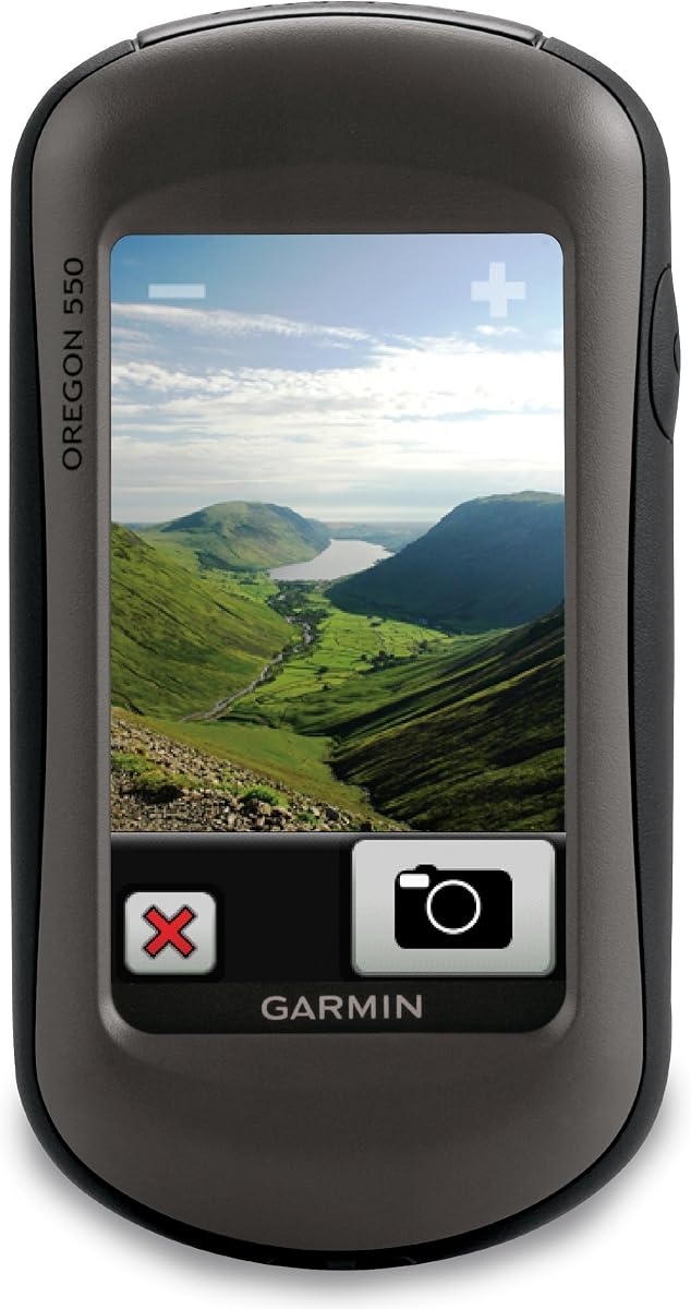
The Garmin Oregon 550 is a classic waterproof GPS device that balances navigation with basic photography features effectively. Its 4.0 rating reflects dependable performance for users who need durable tools without the complexity of newer touchscreen models.
We may earn a commission when you buy through this link, at no additional cost to you.
The 3-inch color touchscreen display provides clear viewing of maps and coordinates. A built-in 3-axis tilt-compensated compass ensures accurate heading even when the device is not held level. Preloaded shaded relief basemap enhances terrain visualization.
While the camera is functional at 3.2 megapixels it lacks advanced zoom features found in higher models. As an older device software updates might be limited affecting integration with modern smartphone ecosystems.
This device suits hikers and geocachers who prioritize water resistance and straightforward touchscreen operation. It offers a reliable combination of essential navigation tools and memory-capture capabilities for everyday outdoor adventures.
The tilt-compensated compass provides accurate heading readings even when walking or moving in uneven terrain.
Preloaded shaded relief basemaps improve terrain understanding making it easier to visualize elevation changes visually.
We may earn a commission when you buy through this link, at no additional cost to you.
The Garmin Oregon 200 serves as a compact entry-level option for those needing basic GPS functions with touchscreen convenience. Its 3.2 rating suggests mixed results often related to battery life and software responsiveness in challenging conditions.
We may earn a commission when you buy through this link, at no additional cost to you.
Key features include a 2.6-inch color display and high sensitivity GPS receiver for quick location acquisition. The unit supports five user profiles which helps differentiate navigation settings for different activities like geocaching or fitness.
Users may experience shorter battery life compared to dedicated hiking GPS models and the touchscreen can be finicky in cold weather. The lack of detailed topographic maps out of the box requires additional purchases for full utility.
This device is suitable for casual users who want a simple handheld GPS for basic tracking. It offers an affordable introduction to touchscreen navigation but may not meet the demands of serious outdoor enthusiasts.
High sensitivity GPS receiver ensures fast signal lock which reduces wait time when starting your geocaching session.
Multiple user profiles allow quick switching between navigation modes tailored for different outdoor activities and preferences.
We may earn a commission when you buy through this link, at no additional cost to you.
Selecting the right handheld GPS requires understanding specific features that impact navigation accuracy and usability in the field. This guide outlines the most critical factors to consider before purchasing.
Display clarity is crucial for reading maps and coordinates under direct sunlight. Color displays offer better map visualization while monochrome screens conserve battery life. Aim for a size of 2.2 inches or larger for comfortable text and map reading without straining your eyes.
Prioritize sunlight-readable displays with anti-glare coatings to ensure visibility during midday hikes. A larger screen reduces navigation errors by providing more space to view waypoints and terrain details.
Battery endurance determines how long you can navigate without recharging. Models offering 20 to 25 hours are standard while others provide hundreds of hours using AA batteries. Rechargeable units are convenient but may limit field usability without access to power sources.
Choose a device with replaceable AA batteries if you plan extended trips where recharging is impossible. Look for battery indicators that help you manage power consumption effectively throughout your outdoor excursion.
GPS alone may struggle in dense forests or urban canyons. Devices supporting multiple systems like GLONASS Galileo or BeiDou provide stronger signals and faster lock-on times. This multi-GNSS support ensures your position remains accurate even in challenging environments.
Verify that the device supports at least two satellite systems to maximize reliability. Advanced signal processing technologies like WAAS and HotFix further enhance accuracy and reduce drift during navigation.
Preloaded maps save time and money by providing immediate navigation data without extra purchases. Topographic maps are essential for hiking and locating hidden caches. Internal memory capacity should be sufficient to store custom maps and route logs.
Check for expandable memory via micro SD cards to add custom map layers. Ensure the device supports paperless geocaching features to download cache descriptions and logs directly into the unit.
Outdoor adventures expose devices to rain dust and physical impacts. Look for IPX7 or IP67 ratings indicating water and dust protection. Ruggedized housings prevent damage from accidental drops or rough handling during hikes.
Prioritize models built to withstand extreme weather conditions if you plan to use them in diverse environments. A durable device ensures longevity and consistent performance over many years of outdoor use.
Dedicated geocaching features like preloaded caches and automatic updates simplify cache hunting. Devices that integrate with mobile apps offer real-time information and easier map transfers. Compass and altimeter sensors help navigate complex terrain more effectively.
Evaluate whether the device supports wireless updates to stay current with cache changes. Built-in navigation aids like track managers and waypoints organize your trips and prevent getting lost in unfamiliar areas.
Modern GPS units benefit from wireless connectivity like Bluetooth and Wi-Fi for easy data transfer. Integration with smartphone apps enables trip planning and route sharing. Compatibility with existing gear such as bike mounts or chest straps enhances versatility.
Ensure the device supports standard communication protocols to sync with other devices seamlessly. Reliable connectivity reduces the need to manually input data saving time and reducing potential errors during navigation.
Prices vary widely from budget-friendly models to high-end units with advanced features. Determine which features are essential versus nice-to-have based on your activity level. Investing in a reliable device often pays off through better navigation and longer lifespan.
Compare total ownership costs including additional map subscriptions or accessories. A higher initial cost might offer better long-term value if it eliminates the need for external devices or frequent replacements.
Begin by setting up your device in an open area away from large metal objects to ensure fast satellite acquisition. Configure user settings like units language and coordinate systems to match local standards. Preload your favorite maps and geocaching data before heading outdoors.
During use keep the device upright with a clear view of the sky to maintain signal strength. Use physical buttons when gloves are worn to avoid touchscreen issues in cold conditions. Regularly check battery levels and manage power-saving modes to extend operational time.
After each outing clean the device with a soft dry cloth to remove dust and moisture. Store it in a protective case to prevent scratches and impacts. Periodically update firmware and maps via software connections to ensure peak performance and feature availability.
For beginners the Garmin eTrex 10 offers an affordable entry point with essential features. It is lightweight easy to use and includes preloaded maps. This makes it ideal for learning navigation basics without overwhelming complexity or high cost.
Smartphones work well in open areas but struggle in dense forests or deep canyons due to weaker signals. Dedicated GPS units provide reliable multi-GNSS support and better battery life for extended trips. They also withstand harsh weather conditions that might damage a phone.
Most devices do not require subscriptions for basic navigation. Some offer optional services like BirdsEye satellite imagery for aerial views. Check the included maps and connectivity features before buying to ensure they meet your needs without extra fees.
Water resistance is crucial since geocaching often happens in unpredictable weather. Look for at least IPX7 rating to withstand rain and splashes. A waterproof device protects internal electronics ensuring your investment lasts through wet hikes and outdoor adventures.
Multi-GNSS support allows the device to connect to multiple satellite networks like GPS GLONASS and Galileo. This increases signal availability and accuracy especially in challenging environments. It reduces navigation errors and improves overall reliability during outdoor tracking.
Modern devices often support wireless syncing via the Garmin Explore app or similar platforms. You can also transfer GPX files through USB connections to your computer. Many devices support paperless caching so you can download descriptions directly without manual entry.
Replaceable AA batteries are ideal for long trips since you can carry spares easily. Rechargeable options are convenient for short outings but require access to power. Choose based on your trip duration and ability to carry backup power sources.
Touchscreens offer intuitive navigation but buttons work better with gloves or in cold weather. Button-based devices often have longer battery life and less accidental input. Consider your typical conditions and personal preference when choosing interface types.
Choosing the right handheld GPS for geocaching depends on balancing features budget and specific outdoor needs. The Garmin eTrex SE stands out for its battery life and connectivity while the eTrex 10 offers excellent entry-level value.
Prioritize features that matter most to your adventures such as display size map preloading and satellite support. A device that matches your usage patterns will provide the most reliable assistance on the trails and during your cache hunts.
Remember that prices and availability change frequently so always check current listings before making a purchase. Investing in a quality GPS device ensures you can focus on the thrill of the hunt rather than navigation struggles.